On March 28, 2025, a major 7.7 magnitude earthquake originated near Mandalay, Myanmar, and shook the Earth as far as Bangkok, about 1,300 kilometers away With aftershocks still rattling the city at the epicentre, the country has lost over 1,600 lives and this number is expected to go up.
Myanmar earthquake updates: March 30, 2025
Following the severe tremors, Mandalay residents found their city infrastructure ravaged. The deadliest natural disaster to hit Myanmar in years damaged critical infrastructure, including an airport, highways and bridges.
People ride motorcycles past a damaged building after a strong earthquake struck central Myanmar, in Mandalay, Myanmar, on March 28, 2025.
| Photo Credit:
Reuters
Another hard-hit city in Myanmar suffered extensive damage, with images from the capital, Naypyidaw, showing rescue crews pulling victims from the rubble of collapsed buildings.

Volunteers work at the site of a building that collapsed after an earthquake in Mandalay, central Myanmar, on March 29, 2025.
| Photo Credit:
AP
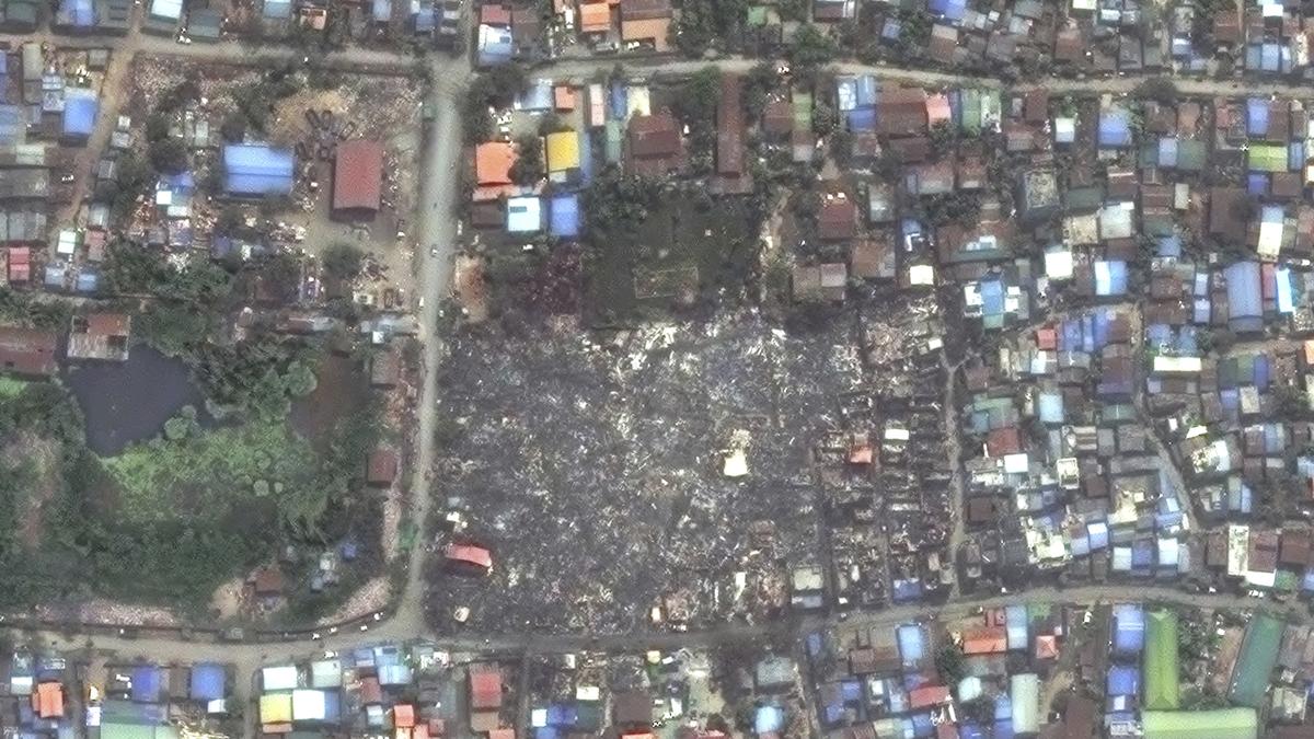
Satellite photos now show the brutal aftermath of the disaster.

This combo satellite photos from Planet Labs PBC show the control tower of the Naypyitaw International Airport in Naypyitaw, Myanmar, Jan. 13, 2025, top, and the same tower collapsed due to an earthquake, on Saturday, March 29, 2025.
| Photo Credit:
AP
With damage to the Naypyitaw International Airport, fights carrying rescue teams from India and China have landed at the airport in Yangon instead of going directly to the airports in the major stricken cities of Mandalay and Naypyitaw.
Also read | Myanmar earthquake: Aftershocks rattle Mandalay as rescuers search for survivors
What caused the earthquake at Myanmar
Experts say the earthquake, which occurred along the Sagaing Fault, was close to the Earth’s surface, generating intense seismic forces. Preliminary estimates by the U.S. Geological Survey show that nearly 800,000 people in Myanmar may have been within the zone of the most violent shaking and that death tolls exceeding 1,000 people, and perhaps much higher, are probable.
Sagaing has been hit by several quakes in recent years, with a 6.8 magnitude event causing at least 26 deaths and dozens of injuries in late 2012.

This combo of satellite images shows the Mahamuni Pagoda and surrounding buildings, before, top, on Sunday March 23, 2025, and collapsed after the earthquake, in Mandalay, Myanmar, on March 29, 2025
| Photo Credit:
AP
But Friday’s event was “probably the biggest” to hit Myanmar’s mainland in three quarters of a century, said Bill McGuire, another earthquake expert at UCL.
Why the March 28 earthquake was so damaging
Roger Musson, honorary research fellow at the British Geological Survey, told Reuters that the shallow depth of the quake meant the damage would be more severe. The quake’s epicentre was at a depth of just 10 km, according to the United States Geological Survey.

This combo of satellite images shows the Ma Shi Kha Na pagoda and surrounding buildings, before, top, on Sunday March 23, 2025, and collapsed after the earthquake, in Sagaing, Myanmar, on March 29, 2025.
| Photo Credit:
AP
“This is very damaging because it has occurred at a shallow depth, so the shockwaves are not dissipated as they go from the focus of the earthquake up to the surface. The buildings received the full force of the shaking.”
“It’s important not to be focused on epicentres because the seismic waves don’t radiate out from the epicentre – they radiate out from the whole line of the fault,” he added.

This combo of satellite images shows shacks and buildings before, top, on Sunday March 23, 2025, and collapsed after the earthquake, in Mandalay, Myanmar, on March 29, 2025.
| Photo Credit:
AP
How prepared were Myanmar cities for the earthquake
The USGS Earthquake Hazards Program said on Friday that fatalities could be between 10,000 and 100,000 people, and the economic impact could be as high as 70% of Myanmar’s GDP.
Musson said such forecasts are based on data from past earthquakes and on Myanmar’s size, location and overall quake readiness.

This combo of satellite images shows the Anada Pagoda and the Pindaya monastery before, top, on Sunday March 23, 2025, and collapsed after the earthquake, in Mandalay, Myanmar, on Saturday March 29, 2025
| Photo Credit:
AP
The relative rarity of large seismic events in the Sagaing region – which is close to heavily populated Mandalay – means that infrastructure had not been built to withstand them. That means the damage could end up being far worse.
Musson said that the last major quake to hit the region was in 1956, and homes are unlikely to have been built to withstand seismic forces as powerful as those that hit on Friday.
“Most of the seismicity in Myanmar is further to the west whereas this is running down the centre of the country,” he said.

This combo of satellite images shows the Inwa bridge over the Irrawaddy River on Sunday March 23, 2025, top, and the bridge collapsed after the earthquake, in Mandalay, Myanmar, on March 29, 2025.
| Photo Credit:
AP

Aid, rescue workers find it hard to reach devastated cities
The entire town of Sagaing near the quake’s epicentre was devastated, said resident Han Zin.
“What we are seeing here is widespread destruction – many buildings have collapsed into the ground,” he said by phone, adding that much of the town had been without electricity since the disaster hit and drinking water was running out.
“We have received no aid, and there are no rescue workers in sight.”

A woman injured by Friday’s earthquake waits to receive treatment at the 1000-bed hospital in Naypyitaw, Myanmar, on March 29, 2025.
| Photo Credit:
AP
Across the Irrawaddy river in Mandalay, a rescue worker said most operations in the country’s second-largest city were being conducted by small, self-organised resident groups that lack the required equipment.
“We have been approaching collapsed buildings, but some structures remain unstable while we work,” he said, asking not to be named because of security concerns.
Hospitals in parts of central and northwestern Myanmar, including Mandalay and Sagaing, were struggling to cope with the influx of injured people, according to the U.N. Office for the Coordination of Humanitarian Affairs.

In this image provided by The Myanmar Military True News Information Team, Myanmar’s military leader Senior Gen. Min Aung Hlaing, center, inspects damaged road caused by an earthquake Friday, March 28, 2025, in Naypyitaw, Myanmar.
| Photo Credit:
The Myanmar Military True News Information Team via AP
India, China and Thailand are among the neighbours that have sent relief materials and teams, along with aid and personnel from Malaysia, Singapore and Russia.
Indian military aircraft made multiple sorties into Myanmar on Saturday, including ferrying supplies and search-and-rescue crews to Naypyitaw, the purpose-made capital, parts of which have been wrecked by the earthquake.
The Indian Army will help set up a field hospital in Mandalay, and two navy ships carrying supplies are heading to Myanmar’s commercial capital of Yangon, said External Affairs Minister S. Jaishankar.
(Text inputs from agencies)
Published – March 30, 2025 12:20 pm IST